Satellite Images Reveal the Devastating Scale of Venezuela’s Twin Earthquakes
On June 24, 2026, Venezuela was struck by a rare and catastrophic seismic event: two powerful earthquakes occurring just 39 seconds apart near the same location. The quakes, measuring approximately 7.2 and 7.5 in magnitude, caused destruction on a massive scale, particularly in the coastal state of La Guaira and surrounding areas including Caraballeda.
This “seismic doublet” phenomenon dramatically amplified the impact, as the second shock hit while structures were already compromised by the first. High-resolution satellite imagery now provides a sobering, objective view of the tragedy’s extent.
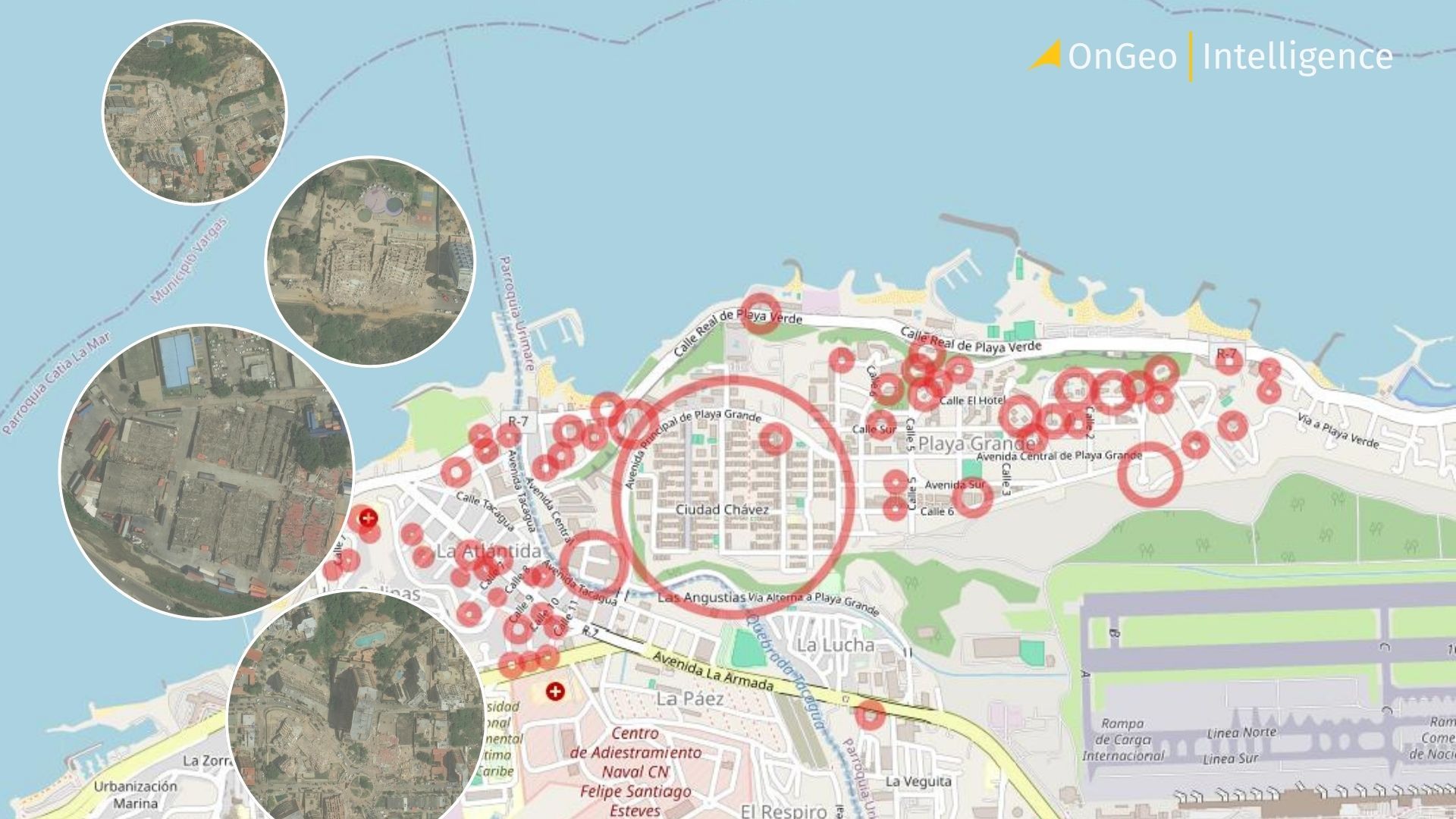
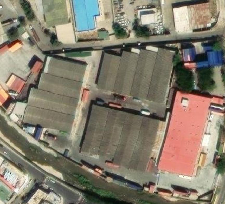
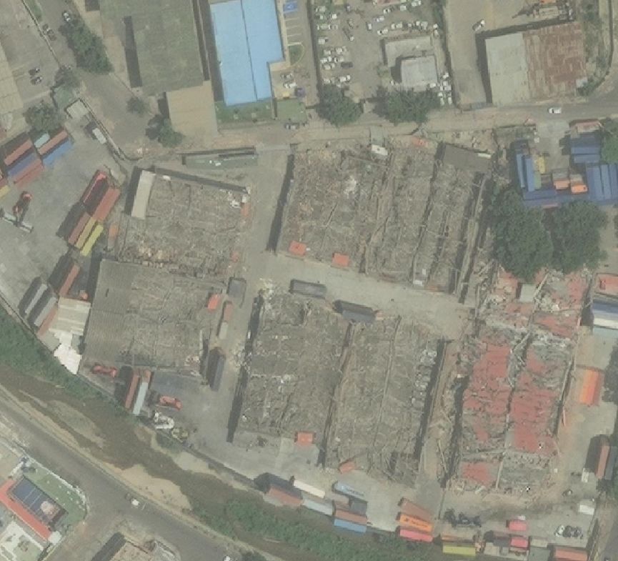
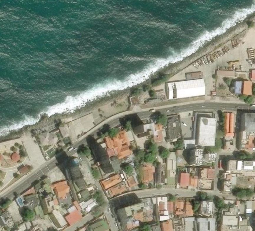
Before-and-After Satellite Analysis: A View from Space
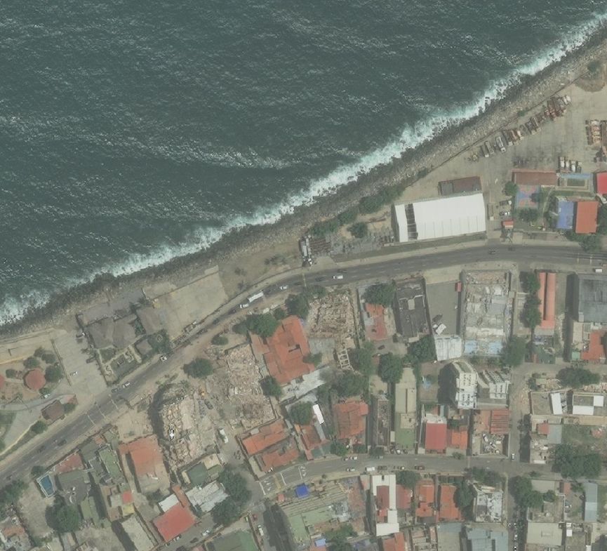
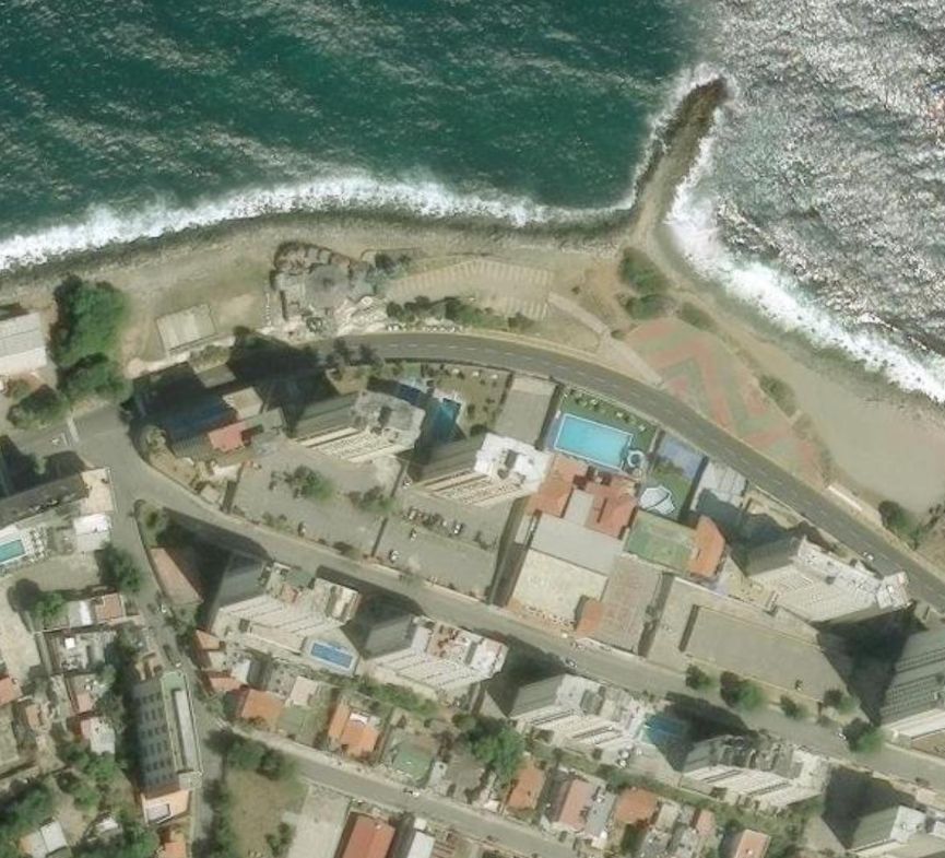
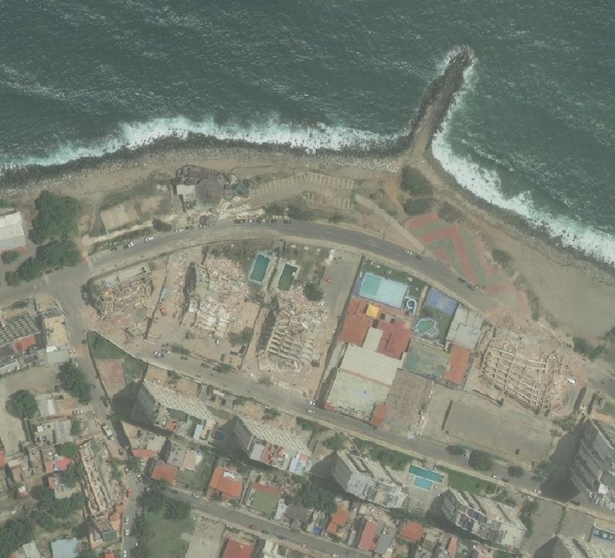
Satellite comparisons reveal shocking transformations in the urban fabric of La Guaira. Pre-earthquake images show densely built coastal neighborhoods with orderly rows of apartment buildings, homes, and infrastructure hugging the shoreline. Post-event imagery displays large swaths of these areas reduced to rubble fields piles of concrete, twisted rebar, and scattered debris where entire city blocks once stood.
In several zones, the destruction appears nearly total. What were vibrant residential districts are now characterized by flattened structures and irregular mounds of wreckage. Roads show visible damage, with some segments blocked by collapsed buildings. The port area and key transportation hubs also exhibit signs of significant impairment, complicating early rescue and aid delivery efforts.
These satellite observations align with ground reports of dozens of buildings pancaked or tilting precariously. The shallow depth of the quakes (around 10 km) further explains the exceptional intensity of surface shaking in this vulnerable region.
Before and after Venezuela Caracas Catia La Mar
The Human and Humanitarian Crisis
The human cost has been heartbreaking. As of June 29, official figures report approximately 235 confirmed fatalities, over 4,300 injuries, and a significant number of people still missing. Many victims remain trapped beneath collapsed multi-story structures, where rescue operations continue around the clock under extremely challenging conditions.
La Guaira has been officially declared a disaster zone and suffered the heaviest losses. A hotel was reduced to rubble, and numerous residential towers sustained catastrophic damage. The broader Caracas metropolitan area also reported structural failures, cracked high-rises, and panicked evacuations.
International humanitarian aid has started to arrive, with rescue teams, medical supplies, and emergency equipment being mobilized from neighboring countries and beyond. However, the sheer volume of destroyed buildings means that every hour counts. Local authorities and volunteers are working tirelessly.
Adding to the tragedy, reports of looting have emerged in affected areas as desperate residents struggle with disrupted supply chains and loss of shelter. Many families have been left homeless, sheltering in makeshift camps or with relatives.
Before and after Venezuela Caracas Macuto
Geological Context and Why This Event Was So Destructive
Venezuela lies along the complex boundary between the Caribbean and South American tectonic plates. This seismic zone is capable of producing major earthquakes, though events of this magnitude are infrequent. The back-to-back nature of the June 24 quakes turned what might have been a serious incident into a national catastrophe.
The coastal location amplified risks: many buildings in La Guaira were constructed in areas with soft soils or near steep slopes, making them more susceptible to strong ground motion. This event is being compared in impact to historical disasters in the region, including the devastating 1999 Vargas tragedy.
The Critical Role of Satellite Technology in Disaster Response
In the immediate aftermath of such events, timely and accurate information is vital. Satellite imagery provides several key advantages:
- Rapid Damage Assessment: Broad-area coverage that helps prioritize search-and-rescue zones.
- Objective Documentation: Unbiased records for insurance, reconstruction planning, and accountability.
- Monitoring Secondary Hazards: Tracking potential landslides, coastal changes, or infrastructure stability over time.
- Support for Recovery: Baseline data for measuring rebuilding progress in the months and years ahead.
OnGeo Intelligence is committed to making high-resolution satellite imagery accessible to governments, NGOs, researchers, and the public. Our platform enables quick generation of before-and-after reports for any location worldwide, empowering faster and more informed decision-making during crises like the one unfolding in Venezuela.
Looking Ahead: The Long Road to Recovery
The people of Venezuela now face the immense task of rebuilding lives and communities. Beyond immediate rescue and relief, long-term challenges include housing reconstruction, infrastructure repair, economic recovery, and strengthening building codes to better withstand future seismic events.
The international community’s sustained support will be crucial in the coming weeks and months. As satellite imagery continues to update the evolving situation on the ground, it serves not only as evidence of destruction but also as a tool for hope guiding resources where they are needed most.