Best Alternatives to Google Earth
By 2026, the virtual globe market has split into two worlds: beautiful 3D exploration and high-stakes satellite intelligence. While Google Earth remains the king of casual browsing and historical time-lapses, it often lacks the real-time "freshness" and analytical depth required by today’s professionals.
Whether you're a researcher tracking environmental shifts, a developer needing 30 cm clarity, or a hobbyist looking for live weather feeds, the landscape of alternatives has never been more robust. From the daily global snapshots of Planet Labs to the open-source power of Sentinel-2, here is the definitive guide to the best Google Earth alternatives in 2026.
The Power Players: OnGeo Intelligence vs. Google Earth
The comparison between Google Earth and OnGeo Intelligence illustrates the primary divide in modern geospatial technology: exploration vs. documentation.
While Google Earth is a window to the world, OnGeo Intelligence is a tool for the record.
Google Earth: The "Universal Canvas"
Google Earth remains the gold standard for context. Its primary strength in 2026 is its massive, pre-rendered 3D environment and the "Timelapse" engine.
- Best For: Virtual tourism, historical fly-overs, and urban 3D modeling.
- The Data: Most of Google’s high-resolution imagery is actually aerial photography (from planes), not satellites. This makes it stunningly clear in cities but means updates can be infrequent, sometimes lagging by 1–3 years in less-populated areas.
- New in 2026: Integration with Gemini AI allows for natural language searches like "find all coastal areas with new construction in the last two years," instantly scanning the globe for visual changes.
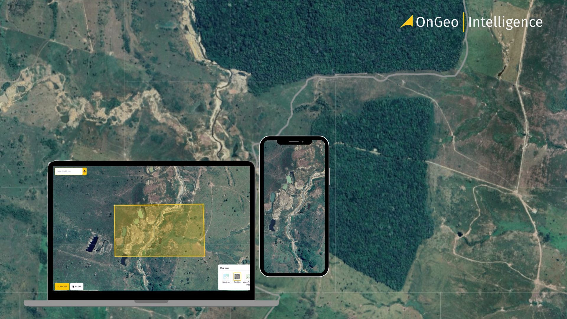
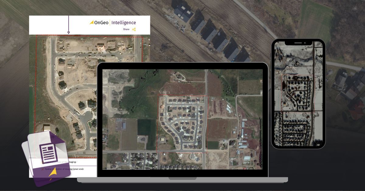
OnGeo Intelligence: The "Legal-Grade" Report
OnGeo Intelligence has carved out a niche for users who need freshness and proof rather than just a pretty picture. It is designed to turn complex satellite data into a simple, professional PDF.
- Best For: Real estate due diligence, insurance claims, legal disputes, and "no-code" environmental monitoring.
- The Data: OnGeo Intelligence provides on-demand access to both free (Sentinel) and commercial satellite constellations.
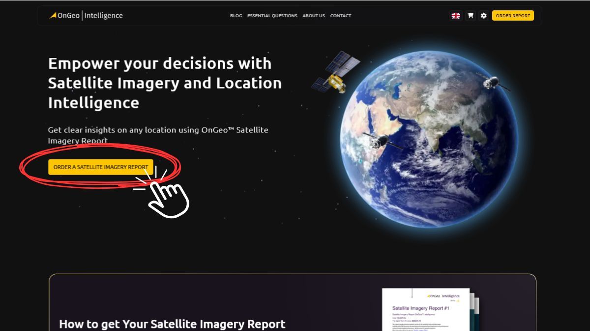
- The "Pay-As-You-Go" Model: Unlike enterprise satellite platforms that require five-figure contracts, OnGeo Intelligence allows users to order a single report for a specific coordinate. There are no subscriptions or GIS software installations required; you simply draw a box on a map and receive a chronologically ordered report of that exact spot.
Comparison at a Glance
Vantor vs. Planet Labs: Resolution vs. Revisit
Vantor.: The "Microscope" (Resolution is King)
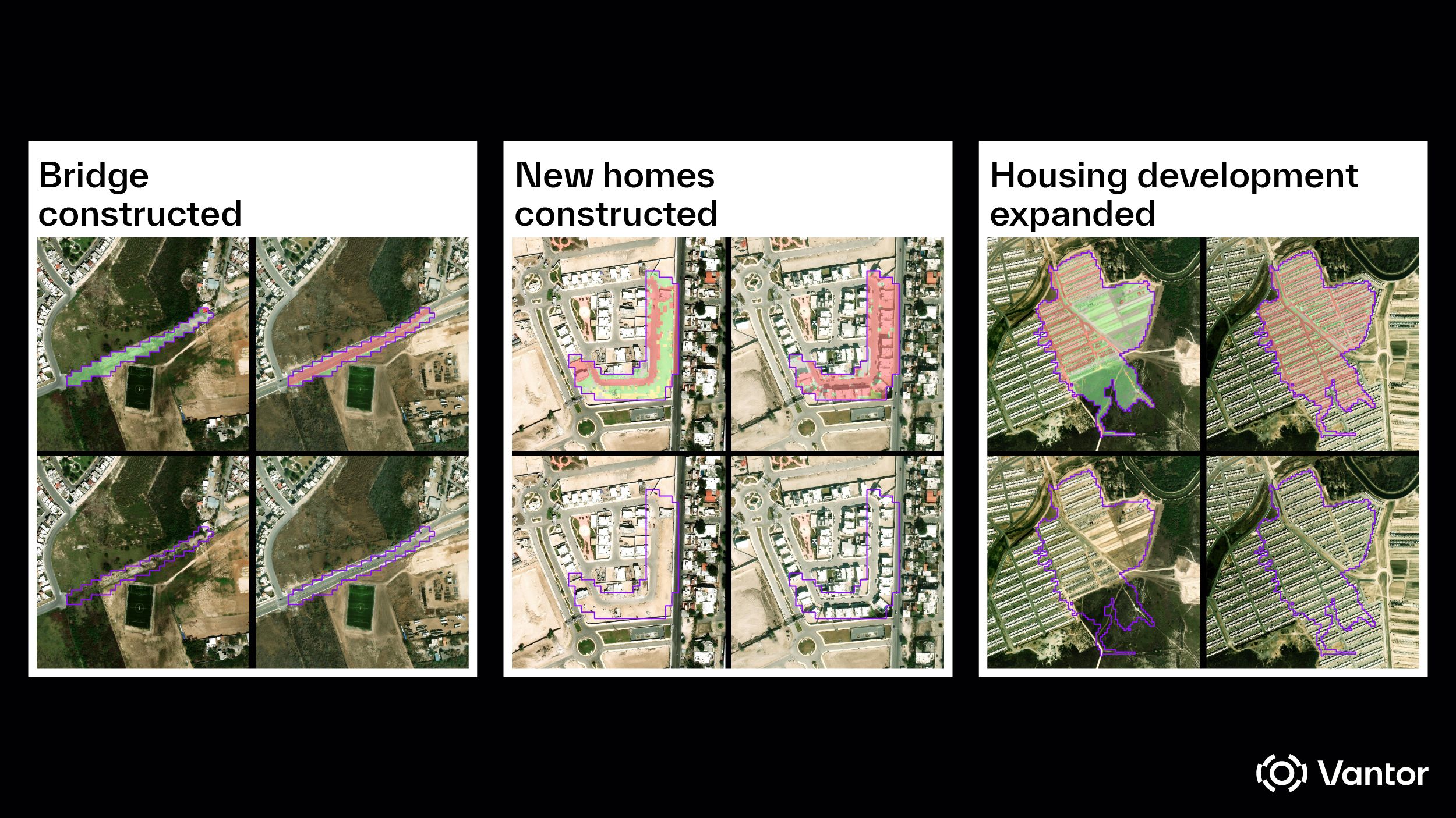
Maxar’s which recently rebranded to Vantor strategy relies on a smaller fleet of massive, high-powered satellites. With the full deployment of the WorldView Legion constellation in 2025-2026, vantor has solidified its position as the provider of the world's sharpest commercial imagery.
- Native Resolution: 30 cm per pixel. This is sharp enough to identify the make and model of a vehicle, detect structural damage to a building, or count the number of shipping containers on a dock.
- The 2026 Edge: The Legion constellation has tripled Maxar's capacity for sub-meter imagery. While they used to have fewer "passes" over a target, they can now revisit high-interest areas up to 15 times per day.
- Spectral Depth: Maxar satellites carry 8 to 29 spectral bands, allowing for advanced "non-visible" analysis, such as identifying specific mineral types in a mine or the moisture content of soil.
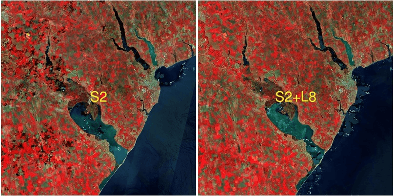
Planet Labs: The "Pulse" (Revisit is King)
Planet’s philosophy is "Daily Earth." Instead of a few massive satellites, they operate a "swarm" of hundreds of small CubeSats (Doves). In 2026, their new Pelican constellation has finally closed the resolution gap with Maxar.
- Native Resolution: Doves: 3–5 meters (Global daily coverage).
SkySats: 50 cm (Tasked high-res).
Pelican (Gen-2): 30 cm per pixel. * The 2026 Edge: Planet’s "Pelican" satellites, equipped with onboard NVIDIA Jetson AI, can process imagery in orbit. This allows for near-real-time "Tip and Cue" workflows: a low-res Dove detects a change (like a ship arriving at a port), and a high-res Pelican is automatically tasked to zoom in on it hours later. - Revisit Frequency: Because they have so many satellites, Planet offers the highest intraday revisit in the industry. They don't just see the world once a day; they capture the "pulse" of a city every few hours.
Head-to-Head Comparison
Which should you choose?
- Choose Vantor if you are an architect, urban planner, or defense analyst who needs the absolute highest geometric accuracy and detail for a one-time or monthly audit.
- Choose Planet if you are in logistics, agriculture, or environmental monitoring and need to know exactly when a change occurred whether it happened at 10:00 AM or 2:00 PM today.
Commercial Pricing: What Does It Cost?
Here is how the pricing breaks down across the industry.
1. The Two Main Purchasing Models
- Archive Imagery (Buying the Past): These are images already sitting in a provider's database. Because the satellite has already done the work, this is the most affordable option. Most archives consider an image "archived" if it is older than 30 to 90 days.
- Tasking (Ordering the Future): You pay a premium to tell a satellite exactly where and when to take a new photo. This is essential for monitoring active construction, disaster response, or verifying a specific event.
2. Resolution vs. Price (Per $km^2$)
Prices are generally calculated by the square kilometer ($km^2$), though every provider has a minimum order size (typically 25 $km^2$ for archives and 100 $km^2$ for new tasking).
3. Subscription vs. One-Off
- The "Netflix" Model (Planet Labs): For ongoing monitoring, Planet offers "Area Under Management" plans. A small business might pay ~$2,700/year to monitor a specific set of locations with daily 3-meter imagery.
- The Marketplace Model (SkyFi / UP42): These act like an app store for satellites. You don't need a contract; you just draw a box on the map, see the price (e.g., $25 total for a high-res archive shot of a neighborhood), and checkout with a credit card.
- The Report Model (OnGeo Intelligence): Designed for non-technical users, no subscriptions or technical skills required, OnGeo removing the need for a GIS expert to "clean" the raw data.
4. Hidden Costs to Watch For
- Cloud Cover Guarantee: Standard tasking usually allows up to 15% cloud cover. If you need a "0% cloud" guarantee, expect a 20%–50% price uplift.
- Rush Delivery: If you need the image within 24 hours of capture (rather than the standard 48–72 hours), "Priority Tasking" can double the base cost.
- Licensing: The "Base Price" usually covers internal use. If you plan to publish the image in a public-facing article or sell it as part of a product, you may need a Media or Redistribution license, which adds a premium.
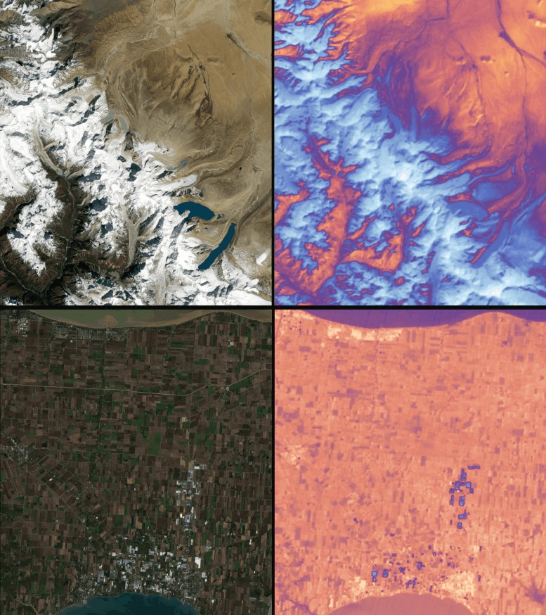
Sentinel-2 (European Space Agency)
By 2026, the Sentinel-2 constellation is fully bolstered by the Sentinel-2C satellite (launched in late 2024), ensuring high-revisit continuity and even faster data delivery.
- Resolution: 10 meters (in Red, Green, Blue, and Near-Infrared bands).
- Revisit Frequency: Every 5 days globally.
- The 2026 Edge: With three satellites (2A, 2B, and 2C) now in orbit, the "blind spots" caused by cloud cover are minimized. It remains the best free tool for vegetation analysis (NDVI) and tracking urban sprawl.
- Best For: Mapping crop health, monitoring water quality, and high-resolution land cover classification.
Landsat 8 & 9 (NASA / USGS)
The Landsat program is the world’s longest-running continuous record of Earth’s surface. While we wait for the next-generation Landsat Next (targeted for the end of the decade), Landsat 8 and 9 remain the workhorses of thermal and historical analysis.
- Resolution: 30 meters (Resampled from 15 m panchromatic).
- Revisit Frequency: 8 days (when combining both 8 and 9).
- The 2026 Edge: Thermal Infrared Sensors (TIRS). Unlike Sentinel-2, Landsat can measure the Earth's temperature. In 2026, this is used extensively to map "urban heat islands" and track the intensity of active wildfires in near-real-time.
- Best For: Long-term environmental change (40+ year archive), surface temperature mapping, and geological mineral exploration.
Sentinel-2 vs. Landsat: Quick Comparison
5. Why OnGeo Intelligence is the Best (and How it Applies)
While the other "Power Players" like Maxar or Planet Labs are built for massive organizations and government contracts, OnGeo Intelligence has become the breakout favorite in 2026 for its sheer accessibility. It is the "bridge" between professional satellite data and everyday users.
Why it is the Best:
- No "Minimum Order" Barrier: Traditionally, satellite companies force you to buy at least 25 $km^2$ of imagery, even if you only need to see a single house. OnGeo allows you to order for a specific, micro-scale area, making high-resolution data affordable for individuals and small businesses.
Ready-to-use reports: Get clean previews, cloud coverage, time-series comparisons, and acquisition dates in a downloadable PDF.
- Zero-Technical Friction: You don’t need to be a data scientist or know how to use QGIS. You simply draw a box on a map, and the system handles the atmospheric correction, cloud masking, and band selection.
Real-World Applications: How it Applies in 2026
Pro Tip: If you are just starting out, use the common industry code "ongeo100" to get a free 10-meter report. It’s the fastest way to see if satellite intelligence fits your specific project.
Learn more about: Satellite Imagery Report
Conclusion: Choosing Your Lens for 2026
The "best" alternative to Google Earth in 2026 isn't a single platform, but rather the one that aligns with your specific mission. As the industry moves from simple "pictures" to "actionable intelligence," your choice depends on whether you prioritize clarity, frequency, or automated analysis.
As we move further into 2026, the shift from static maps to dynamic "Earth observation" is complete. The democratization of these tools means that a solo developer in Nairobi or a land surveyor in Oslo has the same access to sub-meter imagery that was once reserved for intelligence agencies.
By leveraging the AI-driven automation of platforms like OnGeo alongside the massive open-data archives of Sentinel and Landsat, users can now build a comprehensive, multi-layered view of any coordinate on the planet. Whether you are monitoring a remote mining operation or simply verifying a property line, the "eye in the sky" is now a standard part of the modern professional toolkit.
Related articles
- How Satellite Imagery Supports Forest Management
- Urban Planning with High-Resolution Imagery
- Real Estate Development with Satellite Intelligence
- How to Download High-Resolution Satellite Images
- How to Get Satellite Imagery for Free: Complete 2026 Guide
- Understanding Satellite Image Resolution: Low vs High Resolution
- Tracking Urban Changes with SaUrban Change Detection with Satellite Imageryellite Imagery: How Change Detection Reveals City Transformations